Wahweap Hoodoos
Description
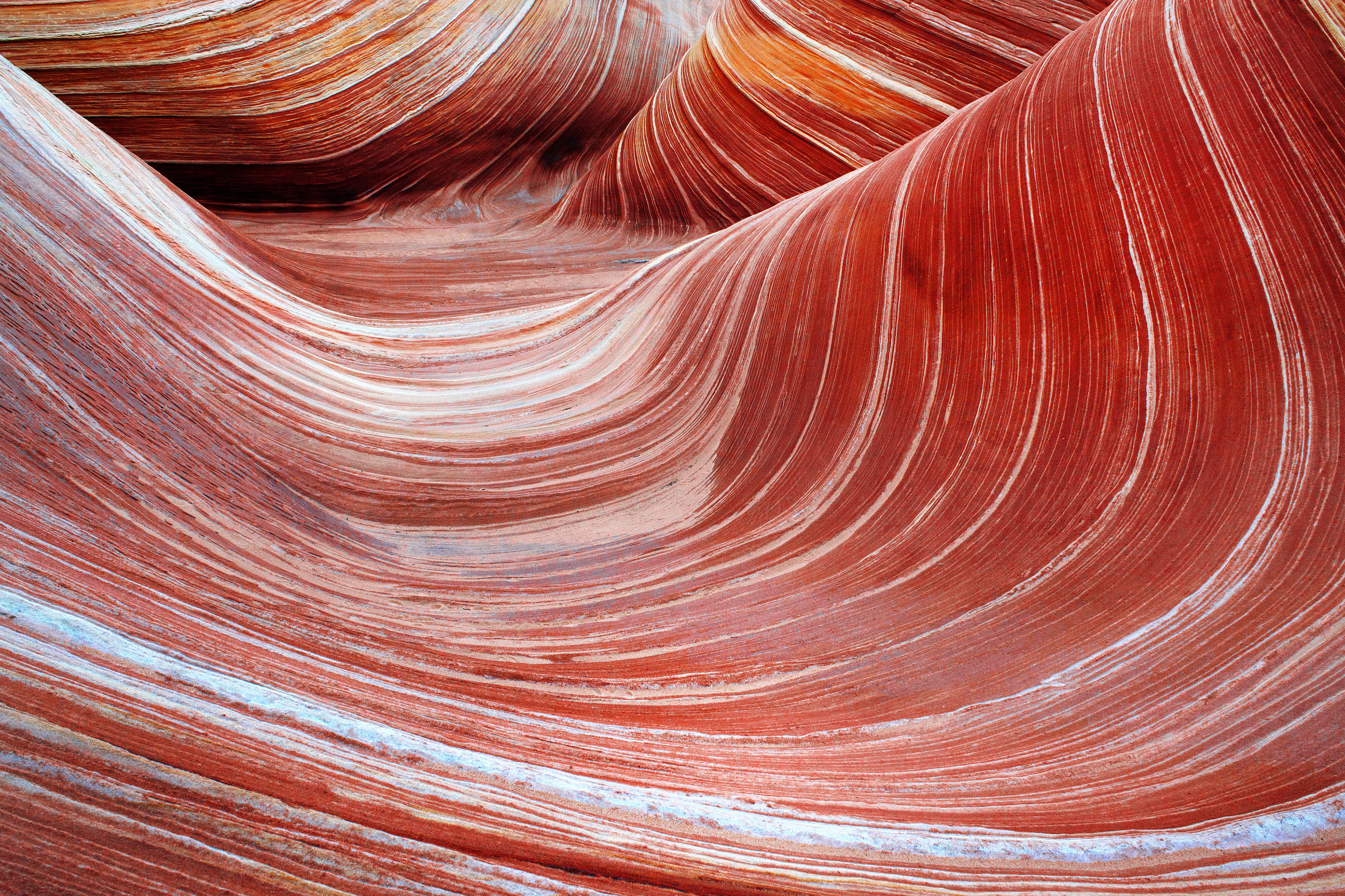
Along the lower reaches of Wahweap Creek, strange rock formations huddle in alcoves along the canyon walls. Ghostly white hoodoos peer out across the broad, empty wash. If you haven’t heard of them before, hoodoos are eccentric columns of rock formed by differential weathering. In this case, the pillars are composed of white Entrada sandstone which has been protected from erosion and weathering by fragments of the harder Dakota formation. These are the brown “capstones” on top of the hoodoos. The Paiutes believed that hoodoos are the remnants of people who were turned to stone. Gaze up into these alcoves, preferably in the early morning or late evening light, and it’s not hard to see why.

The word Wahweap means “bitter water” in Paiute, referring to alkaline seeps that can be found along the canyon. Early settlers used the name Sentinel Rock Creek, likely in reference to the hoodoos.
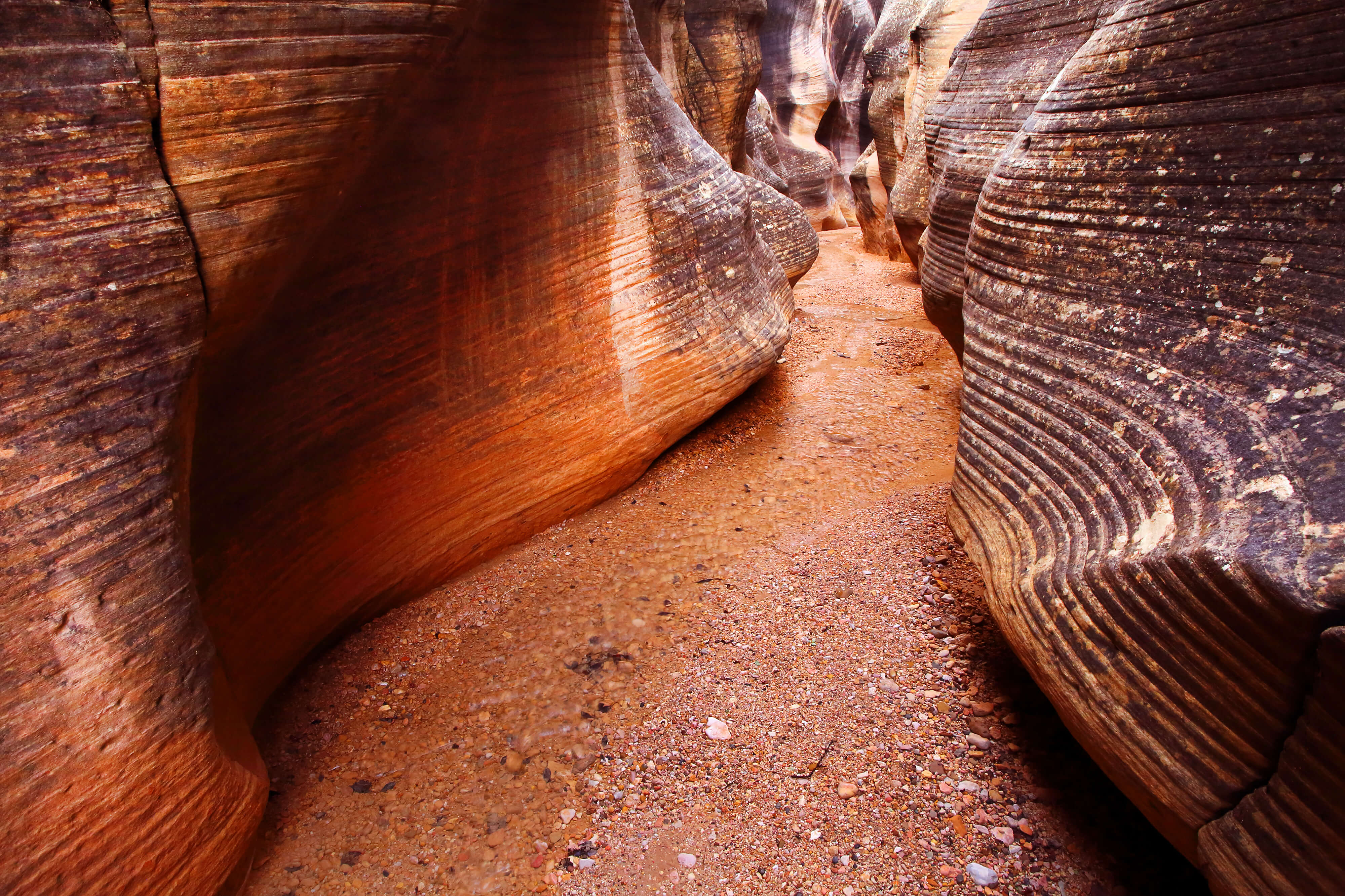
Wahweap Creek is a long, broad drainage that winds over 50 miles from its headwaters on the south slope of Canaan Mountain all the way to Wahweap Bay of Lake Powell. Along the way it slices through multiple layers of the Grand Staircase. Numerous tributaries and side canyons feed into Wahweap Creek. It drains a large area and is prone to flooding. In its lower reaches, the wash is up to a third of a mile wide. When it flows, the creek meanders across the floor of the wash. Depending on the season and storms water may be plentiful, or it may be bone dry.
Follow the creek bed north. The wash makes for a nice stroll with pleasant scenery. About three miles into the hike, those with sharp eyes might spot the first hoodoos far ahead, on the west side of the wash. The next bend of the creek curves right past the base of these formations.
The Wahweap Hoodoos consist of three groupings, or “coves” tucked into the cliffs that bracket the wash. The first cove, also known as “Riverside Cove,” looms immediately above the floor of the wash. It contains some of the largest and most robust hoodoos.
The second cove, also called “Hoodoo Central,” is located in a recess on the canyon wall, around a corner and a third of a mile to the west. These hoodoos cover the spectrum of shape and size, ranging from short and squat to tall and spindly. One prominent and noteworthy hoodoo adorns the northernmost point of this cove. A beaten trail winds close to the pillars, but maintaining a respectful difference will help preserve the fragile formations and the surrounding cryptobiotic soil.

The third cove, also known as “towers of silence,” is a third of a mile to the north, hiding behind a jutting prominence. This cove contains the most delicate and ethereal hoodoos, along with rippled sheets and mounds of white sandstone.
Getting There
From Kanab, drive east on Highway 89 for approximately 55 miles to Big Water, Utah. Between mile markers 6 and 7, turn north onto Ethan Allen Road. The turn-off is directly across the highway from the BLM Grand Staircase-Escalante National Monument Visitor Center. Follow Ethan Allen Road north to a T-junction with Fish Hatchery Road. Turn left and follow the graded dirt road past the fish hatchery ponds. Three miles from Highway 89, you will see a small corral on the right. Shortly after this corral, the road crosses Wahweap Creek and heads north. If driving a 2WD vehicle, park on either side of the road just before it crosses the creek. Two small parking areas are available for this purpose. From there, begin hiking up Wahweap Creek. High clearance, 4WD vehicles can continue across Wahweap Creek, and continue for another 1/3 mile. There is no official trailhead parking lot–just brush and sand. If you miss the sign and keep driving, the road will drop into Nipple Creek after another 1/4 mile. From the 4WD parking area, the trail begins in Wahweap Creek immediately below the road.
Hike north from the confluence of Coyote Creek, Nipple Creek, and Wahweap Creek. The bottom of the wash gains only 240 feet of elevation in about 4.6 miles, so the hike is leisurely and easily navigated. Plan on taking about 2-2.5 hours to hike each way. Patches of clay can be extremely slippery or sticky when wet. After approximately 1/4 mile, a dilapidated fence spans the creekbed, suspended in the air. Continue up the wash. Stay in the watercourse whenever possible, to avoid damaging the fragile desert ecosystem. After about three miles, the first hoodoos can be seen far ahead on the west side of the wash. The next bend of Wawheap Creek heads west, right to the base of the first cove.
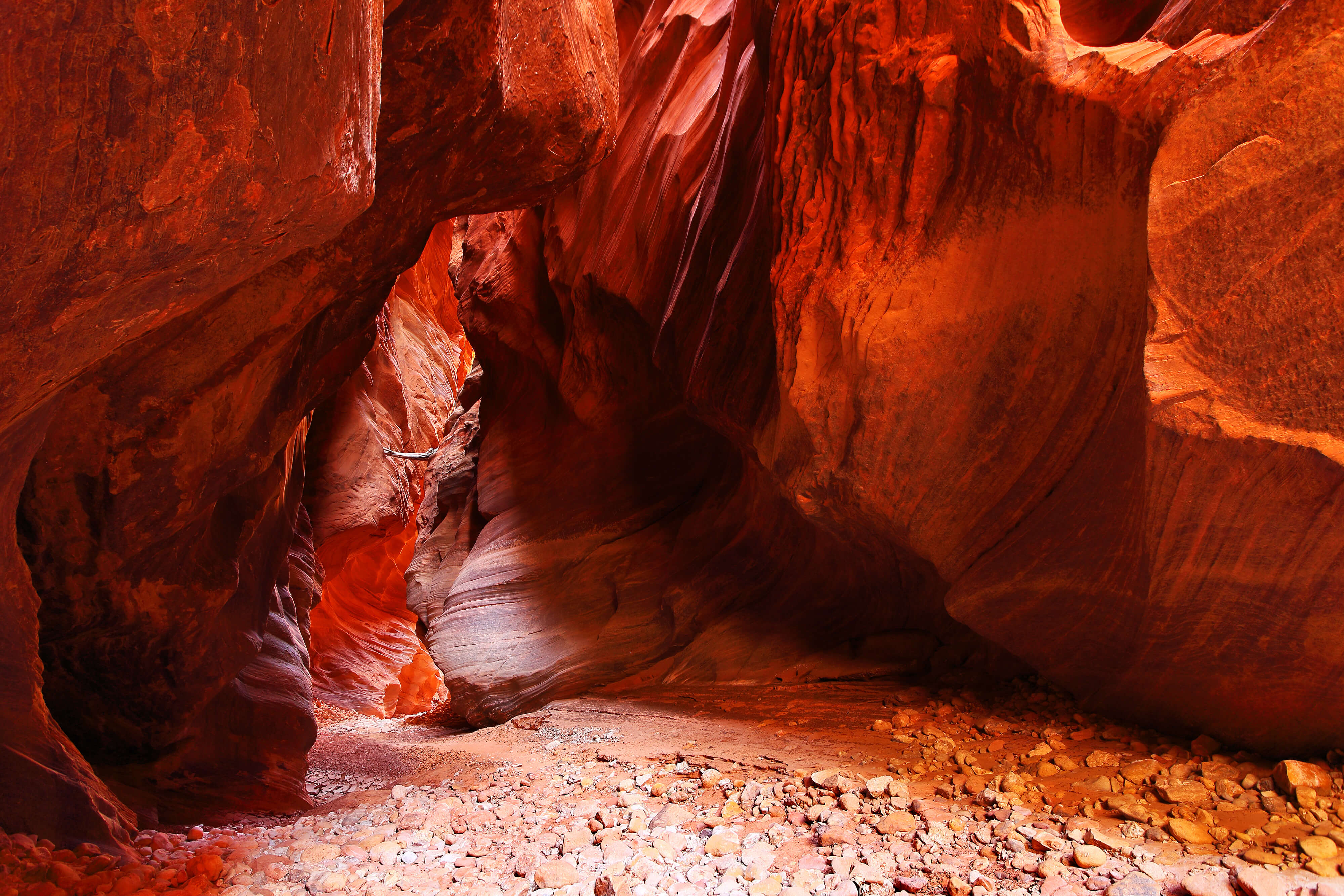
 A dense thicket of tamarisk stands between the first cove and the others. Stay close to the edge of the wash, following along the bottom edge of a white sandstone ledge to avoid as much of the dense tamarisk as possible. This path winds around into a recessed gorge with more hoodoos. This is the second cove. There is a beaten path close to the white columns, but please view the hoodoos from a distance to avoid damaging the fragile sandsstone and surrounding cryptobiotic soil. These spectacular white hoodoos are world-class rock formations; let’s keep the area looking good for the generations to come.
A note about access
At one point the hoodoos were accessible from the north, by driving north on Cottonwood Canyon road, then east on BLM road 431 to a 4WD parking lot on the edge of Wahweap Creek. This was a much shorter route by foot, requiring only a one mile southbound hike to reach the hoodoos. Some websites still incorrectly list this as a viable route. The BLM has closed road 431 to the public indefinitely. Reportedly, some visitors were using this backroad to drive their vehicles down into the wash, which is strictly prohibited. As a result the BLM is taking steps to prevent any access from that direction. This area is actively monitored by the BLM, and bypassing the closure would likely result in hefty fines. The south trailhead and accompanying 4.5-5 mile hike are now the only way to reach the hoodoos.
GPS Coordinates
| 2WD Trailhead | 37.1061 N 111.6867 W |
| 4WD Trailhead | 37.1132 N 111.6877 W |
| Hoodoo Central | 37.1608 N 111.7123 W |

Great stuff, love the descriptions!